CRESTWOOD CITIZENS ASSOCIATIONWASHINGTON, DC | ESTABLISHED 1941 |
Crestwood: 300 Acres, 300 Years, by David Swerdloff, relates the history of our neighborhood with the help of more than 200 vintage photographs, maps, documents and news articles. This 132-page book costs $20, with all proceeds benefiting the Crestwood Citizens Association. Order directly from the Association by contacting info@crestwooddc.org.
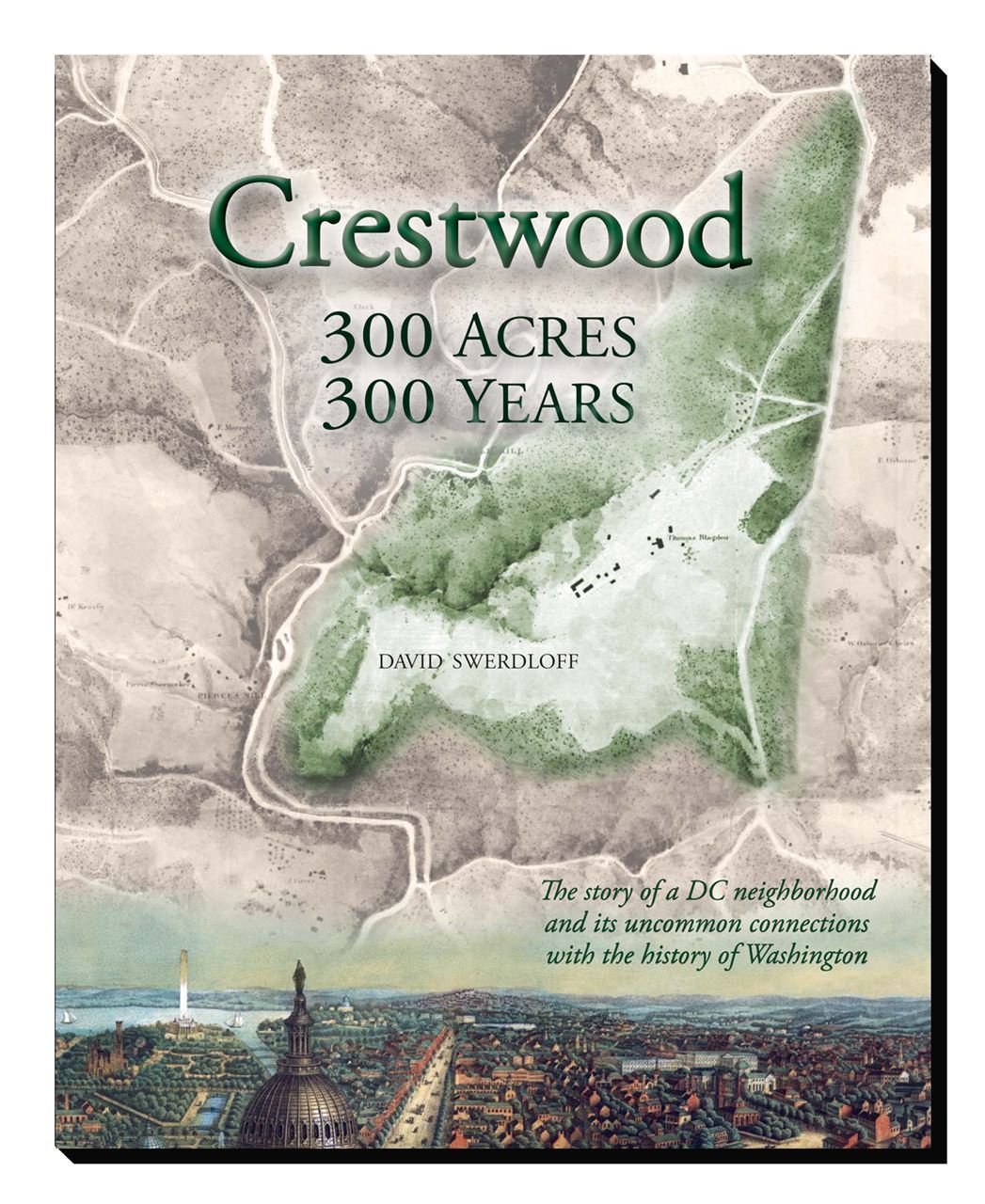
Learn about Crestwood‘s origin as a 300-acre estate first mapped out in 1720—with boundaries that still largely define the neighborhood three centuries later. Meet the many people who traveled to or through the area over the years—including Native American tool makers, Civil War soldiers, horse racing fans, city dwellers looking for an outing “in the country” and U.S. presidents from Abraham Lincoln to Teddy Roosevelt.
The book by Crestwood historian David Swerdloff uncovers links between Crestwood and St. Elizabeth's hospital, the building of the U.S. Capitol, Russian diplomacy, the escape attempt by D.C. slaves aboard The Pearl, the first mass protest march on Washington and four Supreme Court decisions.
Here is a brief summary of David Swerdloff's work:
Brief Crestwood History
Until a century ago, few people lived in the area we now call Crestwood—but many came to and through the area, attracted by what nature provided: a creek that could turn mill wheels, a setting well suited for recreation, paths that led to settlements and forts, and land that could be cleared for crops, commerce and eventually a community of homes.
Our first visitors were Native Americans. While their nearest villages were along the Potomac, Indians would come here to share in the prolific runs of shad, herring and other fish in the creeks, to gather walnuts, and to dig quartzite out of the hillsides below today’s Quincy Street and Crestwood Drive for use in making tools and spear points.
In 1719, Lord Baltimore granted a prominent Maryland settler named John Bradford some 500 acres. He quickly sold 300 acres of it to Randall Blake. That parcel—which Blake named Argyle Cowall and Lorn after three sites along the west coast of Scotland—has pretty closely defined the outlines of Crestwood since the first survey of the tract was made in 1720.
Bradford bought the land back from Blake, and it passed through a number of hands through the 18th century. Along the way, a question of the inheritance of the property was decided by the U.S. Supreme Court.
The nearby mills helped our area come alive. Millwright Isaac Peirce purchased 150 acres along Rock Creek in 1794—then continued to acquire property until he amassed more than 1,200 acres in “Washington County,” the part of D.C. beyond the city limit (today’s Florida Avenue). Along with his son, stonemason Abner Peirce, Isaac constructed Peirce Mill in 1829—plus several other structures that also survive today next door to Crestwood.
Before erecting Peirce Mill, the Peirces built a nearly identical mill on the Argyle Cowall and Lorn parcel that became Crestwood. The Argyle mill was located in the clearing you see today below Boulder Bridge along Beach Drive.
The first owner of the Argyle parcel to make major improvements was Alexander de Bodisco, who purchased the property in 1845 for $7,500. The large house he built on the hilltop near present-day 18th and Varnum Streets was torn down in 1934. Bodisco was Russia’s ambassador to the United States and a very popular diplomat. In 1839, at one of the many parties he threw in Georgetown, he met a 16-year-old local beauty named Harriet Beall Williams. At their wedding in 1840, he was 53—and the match was often described as “Beauty and the Beast.”
Shortly before Bodisco died in 1854, he sold the Argyle property to lumber merchant and real estate tycoon Thomas Blagden, whose father George had been the chief stonemason for the construction of the U.S. Capitol. Thomas Blagden had owned an estate on a different wooded bluff overlooking the city. But social reformer Dorothea Dix persuaded him to let the federal government buy that tract—called St. Elizabeths—to become the site of a mental hospital. With the $25,000 Blagden received (and despite a case of seller’s remorse for letting the property go for much less than he thought it was worth), he purchased the land that would become our neighborhood. By the time he died in 1870, Blagden built up the estate to include not only a profitable mill complex, but also 15 other buildings—including the mansion house, carriage house, farmhouse, barn, ice house, gardener’s house, grapery and “bowling saloon.”
To the north of the Argyle tract was an important Civil War showdown. The Battle of Fort Stevens blocked Confederate forces from taking Washington in July 1864. Union troops passed through the Argyle estate and may have camped here. Abraham Lincoln rode through our neighborhood on his way to the fort—where he would become the only sitting U.S. president to come under enemy fire. Lincoln traveled along Piney Branch Road, which used to come up the hill from Mount Pleasant behind where the Crestwood Apartments are today. Other old streets in the area included Blagden Mill Road (which connected the Argyle mill complex with Piney Branch Road along today’s Colorado Avenue) and Broad Branch Road (which dates back to 1839).
When slavery was abolished in DC in 1862, slave owners could apply for compensation for losing their “property.” We know from these records that the Peirces owned many slaves. Thomas Blagden applied for compensation for three slaves. Two of them were teenagers living on the estate; they were to have remained indentured servants until they were 25. A third man was living independently, but under the requirement that he earn enough money to pay Blagden $500 for his service. Free blacks also had been residing in the area and working as tenant farmers, laborers, gardeners, laundresses and housekeepers— including on the Blagden estate.
Rock Creek Park was established in 1890. By then the mills along the creek had either been abandoned or become outmoded. Park authorities allowed the ruins of Blagden’s Argyle mill complex to be destroyed in 1899 for the construction of Beach Drive. Thomas Blagden’s son—also named Thomas—ceded nearly 39 acres to the new park. He also fenced in his own “deer park”—a large area where he bred deer, an animal that had long disappeared from the Rock Creek valley. Blagden, along with Peirce heir Louis Pierce Shoemaker, would be instrumental in bringing more roads into the area—including the extension of 16th Street across an impressive bridge spanning the Piney Branch.
Although the plan for Rock Creek Park called for the protected forest to extend east to 16th Street nearly everywhere north of the Argyle tract, some areas had already been developed. A resort named Crystal Springs had been built about where the tennis stadium is today; it had disappeared by the time the Park was approved. But just northeast of that site was a racetrack that didn’t close down until 16th Street bisected it in 1909. Operating under names such as Piney Branch Trotting Course and Brightwood Driving Park, it offered popular harness races—plus bicycle races, occasional baseball games and Washington’s first automobile races. When “Coxey’s Army”—a group of unemployed workers demanding public works projects following the Panic of 1893—marched on the Capitol in 1894, they left their final camp at the race course and trekked through the future Crestwood into town along Piney Branch Road.
When the elder Thomas Blagden died without a will, the Argyle property was split among various members of the family. It appeared on real estate maps as early as 1876 as the “Blagden Subdivision”—yet no serious attempts were made to develop the land until the turn of the century.
The D.C. Commissioners issued a plan in 1901 for naming the streets that would eventually extend into Crestwood. The plan called for numbered streets traveling north and south—while east-west streets would run in alphabetical order and be named after famous Americans. Thoroughfares that had been called Savannah, Trenton, Utica, Vallejo, Yuma, Zanesvillle, Albemarle and Brandywine Streets were changed to Taylor, Upshur, Varnum, Webster, Allison, Buchanan, Crittenden and Decatur.
Blagden himself may have developed first two new homes in the Blagden Subdivision. These frame houses at 1608 and 1611 Upshur Street date back to 1900, and are the oldest homes still standing in Crestwood. When 16th Street opened to traffic through the neighborhood in 1910, development began in earnest, centered along the triangle created by 16th Street, Blagden Avenue and Decatur Street (since residents could walk down Decatur to get to the 14th Street trolley).
While the neighborhood was developed mostly on a piecemeal basis, there were larger housing developments called Mount Pleasant Heights (1905), Argyle Park (1907) and Blagden Park (1926). The neighborhood’s most distinctive property was built in 1927 for Mona Blodgett and her new husband David St. Pierre Gaillard. Called “The Rocks,” it was named after the Gaillard family plantation in South Carolina. At the same time, a second home was built on the other side of Rock Creek for Mona’s elder sister Helen and her new husband. It was called Abremont, but took on the new name Hillwood when it was purchased later by Marjorie Merriweather Post.
The development called Crestwood wasn’t established until 1938 on the south end of the neighborhood, on a site described as “wooded country in the downtown residential district and only 10 minutes from the White House.” The developers, led by Paul Stone, would market “Homes of Tomorrow” with such modern amenities as air conditioning and dishwashers.
In 1941, after plans were announced to build a six-story apartment house at 16th and Shepherd Streets, Crestwood residents organized to oppose the project by forming the Crestwood Citizens Association. The group’s campaign of lobbying, lawsuits, petitions and Congressional testimony led to two U.S. Supreme Court rulings and an eight-year delay before construction of the Crestwood Apartments got underway at the end of 1949 or the beginning of 1950.
The Association fulfilled other civic and social roles during the 1940s, especially during World War II. Members patrolled the Crestwood Civil Defense District and organized a victory garden on three acres of undeveloped land bounded by Argyle Terrace and 18th, Shepherd and Taylor Streets. They planted a community Christmas tree at 18th and Shepherd, and chose the azalea to be the community flower.
Large parts of the area had been “restricted”—with language inserted into deeds forbidding ownership by blacks, Jews and other minorities. The Supreme Court ruled in 1948 that these restrictions could not be enforced. The decision—and the integration of public schools—helped open up the neighborhood to all. As a result, while the 1950 Census showed only a handful of African Americans in Crestwood (Census Tract 26), the number of black and white residents was nearly equal in 1960—and by 1970 almost two-thirds of neighborhood residents were African American. Today Crestwood is one of D.C.’s most diverse communities.
A bombing shook Crestwood in June, 1980. A Croatian nationalist group claimed responsibility for the pre-dawn explosion outside 1907 Quincy Street. No one was injured, but the blast caused about $200,000 in damage.
In recent decades, the Association and other community organizations have continued to focus on conserving the residential character of a neighborhood that first appeared as a single estate nearly 300 years ago. Crestwood residents can still agree with British Ambassador Lord James Bryce, who in 1913 noted there was “nothing comparable in any capital city in Europe” to our setting by Rock Creek:
“What city in the world is there where a man living in a house like that in which we are meeting, in 18th Street, can within . . .a quarter of an hour on his feet get into a beautiful rocky glen, such as you find in the woods of Maine or Scotland . . .with a broad stream foaming over its stony bed and wild, leafy woods looking down on each side?”
STREET NAMES(there is more street name information in David Swerdloff's history blog, here and here)
Who are our streets named after? Here’s our latest best guess:
Allison Street — :It could have been named after William Boyd Allison (1829-1908), a US Senator from Iowa for 35 years. However, he was still alive in 1901 when the street got its name—and roads are generally named after the deceased.
Argyle Terrace — The name was passed down from Randall Blake’s original Maryland colonial land patent for our neighborhood—for a tract he called “Argyle Cowall and Lorn.”
Blagden Avenue/Terrace — The Blagden family owned the Argyle estate beginning in 1853.
Buchanan Street — James Buchanan (1791-1868) was US President from 1857 to 1861.
Colorado Avenue — One of the DC avenues named after US states.
Crestwood Drive — This road was named after Paul Stone’s Crestwood development, which got its start in 1938.
Crittenden Street — This is the name of a family of military and political leaders in Kentucky, Missouri and Virginia. Most notable may have been John Jordan Crittenden (1786-1863), who served as a US Senator, Congressman, Attorney General and Kentucky Governor. He is remembered for the 1860 Crittenden Compromise, an unsuccessful effort to keep the South in the Union by guaranteeing the permanent existence of slavery in the slave states and any place south of 36 degrees, 30 minutes latitude.
Decatur Street — Naval officer Stephen Decatur (1779-1820) was hailed as a hero during the Barbary Wars and the War of 1812. Eventually named Commissioner of the Navy, he died of a pistol wound after a duel in Bladensburg.
Mathewson Drive — Harriet Silliman Blagden, one of the daughters of the first Thomas Blagden, married Brooklyn doctor Arthur Mathewson. After Blagden’s death, the Mathewsons became property owners in the neighborhood.
Quincy Street — The road could have been named for President John Quincy Adams, who owned Adams Mill (located where the National Zoo is today). Other notable Quincys included Revolutionary War Colonel Josiah Quincy and various lawyers, Boston mayors and Harvard presidents.
Randolph Street — The Randolphs were a prominent Virginia family. John Randolph (1773-1833) was a powerful Congressman and Senator—and the subject of Whittier’s poem Randolph of Roanoke. Peyton Randolph (1721-1775) was the first president of the Continental Congress. His nephew, Edmund Randolph, became the first US Attorney General.
Shepherd Street — Alexander Robey Shepherd (1835-1902) earned the nicknames “Boss Shepherd” and “the Father of Modern Washington” for his efforts to upgrade the city as head of the DC Board of Public Works and later Governor of the District of Columbia. His public works projects also put the city $13 million in debt.
Taylor Street — This name was probably inspired by military hero and US President Zachary Taylor (1784-1850).
Trumbull Terrace — Historical paintings of the Revolutionary War by American artist John Trumbull (1756-1843) hang in the Capitol rotunda (and one appears on the back of the $2 bill). Alternatively, Lyman Trumbull (1813-1896) was a US Senator from Illinois who co-authored the 13th Amendment prohibiting slavery.
Upshur Street — Abel Upshur (1790-1844) served as Secretary of the Navy and Secretary of State. He was among eight people killed when a gun exploded aboard the USS Princeton while President Tyler, his cabinet and about 200 guests were cruising along the Potomac to celebrate the launch of the new steamship.
Varnum Street — Joseph Bradley Varnum (1751-1821) was a Congressman from Massachusetts and Speaker of the House under two presidents. His brother, James Mitchell Varnum (1748-1789), represented Rhode Island in the Continental Congress. As a general in the Continental Army during the Revolutionary War, he advocated allowing African Americans to enlist in the army—resulting in the all-black First Rhode Island Regiment.
Webster Street — The possible inspirations include Daniel Webster (1782-1852), US Senator from Massachusetts and Secretary of State under three presidents—and Noah Webster (1758-1843), author, spelling reformer and creator of the modern dictionary.